Captain Segulls
Florida Panhandle Sportfishing Nautical Chart Package- HUGE SAVINGS
Florida Panhandle Sportfishing Nautical Chart Package- HUGE SAVINGS
Couldn't load pickup availability
Free USA Shipping
THE ULTIMATE PACKAGE OF FISHING CHARTS
COMPLETE COVERAGE OF FLORIDA PANHANDLE
ALL CHARTS INCLUDED BELOW
HUGE SAVINGS

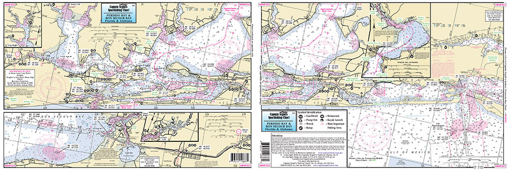
Perdido Bay to Bon Secour Bay-BSP322
Small Boat/Kayak Inshore fishing chart, double sided, laminated, 12 x 18 inches, Florida & Alabama
Detail from Pensacola entrance to Bon Secour River, AL, detail of Perdido & Wolf Bays, FL . All charts include wrecks, reefs, shoals, rigs, fishing areas, amenities and restrictions.Please refer to our nearshore, offshore and other small boat/kayak charts in this area.
Florida Pensacola Bay and Escambia Bay-PEB323
Small Boat/Kayak Inshore fishing chart, double sided, laminated, 12 x 18 inches, Florida
Detail of Pensacola Bay from Tiger Point to Big Lagoon north to Escambia Bay, FL. All charts include wrecks, reefs, shoals, rigs, fishing areas, amenities and restrictions. Please refer to our nearshore, offshore and other small boat/kayak charts in this area.
Choctawhatchee Bay to Hummock Point-CWB314
Small Boat/Kayak Inshore fishing chart, double sided, laminated, 12 x 18 inches
Detail of Fort Walton Beach with all of Choctawhatchee Bay with an inset of Niceville. All charts include wrecks, reefs, shoals, rigs, fishing areas, amenities and restrictions.
Inshore: St Joseph and St Andrew Bays - AJ137 Large
An inshore chart 1-2 miles off the coast detailing the bay. Chart is 19 x 26 inches double sided and laminated. St Joseph & St Andrew Bays, FL
An inshore chart highly detailed of St Joseph & St Andrew Bays, and Chocatawhatchee Bay FL. All charts include wrecks, reefs, shoals, fishing areas, amenities and restrictions.
Apalachicola Bay and River and St Vincent Sound - AB333
Small Boat/Kayak Inshore fishing chart, double sided, laminated, 12 x 18 inches, Florida
Detail inshore of the Apalachicola Bay & River, with St Vincent Sound and Lake Wimico, FL. All charts include wrecks, reefs, shoals, rigs, fishing areas, amenities and restrictions.
Florida Saint Marks River-SMR320
Small Boat/Kayak Inshore fishing chart, double sided, laminated, 12 x 18 inches, Florida
Detail inshore of Saint Marks River north to Route 98 bridge and south and west to Waveland, FL. All charts include wrecks, reefs, shoals, rigs, fishing areas, amenities and restrictions.
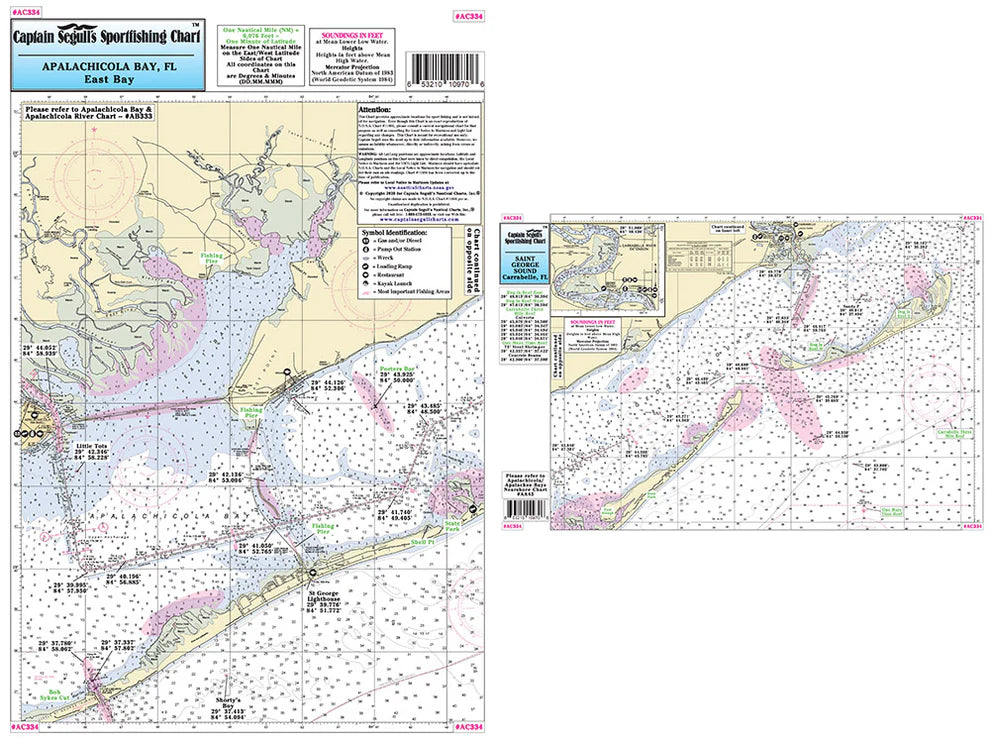
Apalachicola and East Bay to St George Sound - AC334
Small Boat/Kayak Inshore fishing chart, double sided, laminated, 12 x 18 inches, Florida
Detail inshore of the Apalachicola & East Bay to St George Sound, with Carrabelle River, FL. All charts include wrecks, reefs, shoals, rigs, fishing areas, amenities and restrictions
Florida Pepperfish Keys to St Marks River-PSM390
Small Boat/Kayak Inshore fishing chart, double sided, laminated, 12 x 18 inches, Florida
Detail inshore of Pepperfish Keys to St Marks River, FL. Loads of fishing spots. All charts include wrecks, reefs, shoals, rigs, fishing areas, amenities and restrictions. Please refer to our nearshore, offshore and other small boat/kayak charts in this area
Crystal River to Pepperfish Keys-CPS389
Small Boat/Kayak Inshore fishing chart, double sided, laminated, 12 x 18 inches, Florida
Detail inshore of Crystal River to Pepperfish Keys, FL. Loads of fishing spots. All charts include wrecks, reefs, shoals, rigs, fishing areas, amenities and restrictions. Please refer to our nearshore, offshore and other small boat/kayak charts in this area
Florida Crystal River to Rock Islands-SUW41 Large
Nearshore 20 - 30 miles off. Chart is 19 x 26 inches, double sided, and laminated Florida coastline
Side A: from Crystal River to Pepperfish Keys with a detail of Cedar Keys and Suwannee River. Side B: from Horseshoe Cove to Perry Island Creek, FL. All charts include wrecks, reefs, rigs, shoals, fishing areas, amenities and restrictions
Florida Nearshore: Apalachee Bay, Apalachicola Bay to Cape San Blas - AA45 Large
Nearshore 20 - 30 miles off. Chart is 19 x 26 inches double sided and laminated Florida coastline
Side A: from Rock Point to Crooked River Apalachee Bay. Side B: from St George Sound to west of St Joseph's Peninsula. All charts include wrecks, reefs, shoals, fishing areas, rigs, amenities and restrictions. Also refer to our inshore, nearshore, offshore and small boat/kayak charts.
Florida St Joseph, St Andrew and Choctawhatchee Bays-JAC46 Large
Nearshore 20 - 30 miles off. Chart is 19 x 26 inches, double sided, and laminated. Florida coastline
Side A: St Joseph Bay to Laguna Beach, with St Andrews Bay. Side B: from Laguna Beach to Wynnehaven Beach, FL , Choctawhatchee Bay. All charts include wrecks, reefs, shoals, rigs, fishing areas, amenities and restrictions. Please refer to our nearshore, inshore, offshore, and small boat/kayak charts in this area
Pensacola, FL and Mobile Bay, AL-PM47 Large
Nearshore 20 - 30 miles off. Chart is 19 x 26 inches double sided and laminated Florida and Alabama coastline
Side A: from Romar Beach west to Bayou La Batre, includes all of Mobile Bay and an inset of the Mobile Ship Channel northern end. Side B: from Wynne Haven Beach west to Romar Beach, includes Santa Rosa Sound, Pensacola Bay and Perdido Bay. All charts include wrecks, reefs, rigs, shoals, fishing areas, amenities and restrictions.
Fishes of the Gulf of Mexico and Florida Identification Chart-FG504 Large
60 different fish identified, double sided, laminated, 19 x 26 inches
Fish Identification chart. Shows you what fish you just caught. Explains the structure of the fish and special quailfications of a fish. A depiction of 60 fish found in and around the Gulf of Mexico and Florida.
Shark Identification Chart SK502 Large
24 different sharks identified double sided 19 x 26 inches
Twenty-four different sharks depicted. Scientists from Woods Hole, MA consulted giving the most scientifically correct pictures of local sharks that are caught in the Atlantic Ocean. Also describes anatomy of a shark and shows pictures of the teeth structure.