LITOGRAFIA ARTISTICA CARTOGRAFICA
Mont Blanc (Monte Bianco) Panoramic Raised Relief Map
Mont Blanc (Monte Bianco) Panoramic Raised Relief Map
Couldn't load pickup availability
Free USA Shipping
-
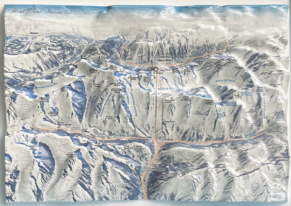
Mont Blanc, or Monte Bianco in Italian – the highest peak in the Alps, Italy, France, and all of Western Europe – is captured in stunning detail in this panoramic raised relief map. With an altitude of 4,805.59 m above sea level, this region of the iconic mountain range comes to life, offering a 3D visual representation of its majestic ridges, peaks, and valleys.
The map beautifully highlights the contrast between the gentle French side and the steep granite walls of the Italian side, which plunge dramatically from the summits into the valleys of Val Ferret and Val Veny. The intricate raised contours allow you to explore the rugged topography that climbers and mountaineers know so well. This unique, tactile map makes it easy to visualize the challenging climbing routes and the impressive peaks that define Mont Blanc (Monte Bianco).
Here are some of the most emblematic peaks featured in the map:
The Dente del Gigante (4,014 m): A towering summit that rises 160 meters above the iconic snow "gum", offering a striking relief feature on the map.
The Grandes Jorasses (3,825 m): This jagged ridge, full of glaciers and spires, is rendered with exceptional topographic detail.
The Aiguille Noire de Peuterey (3,773 m): A symbol of the Italian side of Monte Bianco, it is prominently featured in raised relief, emphasizing its sharp vertical profiles.
The Dôme du Goûter (4,306 m): The map highlights the expansive flat summit of the Dôme, the largest and most striking summit in the entire Alps.
The Mont Dolent (3,820 m): A pyramidal peak where the borders of Italy, Switzerland, and France converge. This distinctive peak is rendered with precision to show its location as a key geographical point.
The Guggie di Chamonix (between 3,000 and 3,842 m): Dominating the Chamonix valley, these spires are showcased as one of the most iconic landscapes in the French Alps.
The panoramic raised relief feature adds an extraordinary layer of depth, allowing you to feel the elevation changes and experience the full scale of these majestic mountains in a tactile, interactive way. Whether you're a mountain enthusiast, a collector, or just captivated by the beauty of the Alps, this map brings the towering Mont Blanc (Monte Bianco) to life, offering an immersive and educational experience.
- Type: Flat Map
- Subtype: Raised Relief
- Language: Italian
- Publication Date: 2025-05-01
- Regions Covered: Alps, Europe, Western Europe
- Countries Covered: France, Italy
- Folded Size: N/A
- Unfolded Size: 24" (W) x 18" (H)
-
Weight: 5 lb