GEO-SITU
Mt. Shasta, California lapel pin
Mt. Shasta, California lapel pin
Regular price
$19.95 USD
Regular price
Sale price
$19.95 USD
Unit price
per
Shipping calculated at checkout.
Couldn't load pickup availability
Free USA Shipping
-
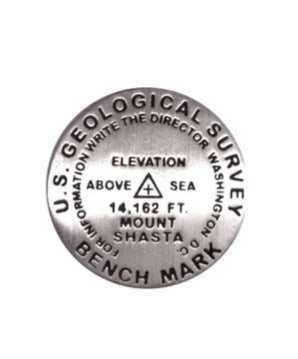
- 1 inch diameter Cast in fine pewter Military clutch back Mounted on story card PLACE NAME: Mount Shasta ELEVATION: 14,162 ft. (Elevation from GNIS database.) COORDINATES: N41° 24' 34'' W122° 11' 38'' LOCATION: Shasta National Forest, California, USA Like Mount Rainier to the north, the massive Mount Shasta, was formed by ice and fire and is a volcano at rest. It shoulders 8 magnificent glaciers and dominates the region's landscape. Meadows of wildflowers and groves of Shasta Red Fir characterize its flanks. Abundant in mystic lore, trails, and opportunities for peak experiences, the beloved mountain has something for everyone. Early explorers and expeditions included: Spanish explorer Fray Narcisco Duran who published the first recorded sighting (1817); the Wilkes expedition who published the first known illustration (1841); Captain John Fremont (1947); and Robert S. Williamson, railroad topographer (1855).
- Type: Lapel Pin
- Subtype: Pins
- Language: English
- Regions Covered: North America, Western U.S.
- Countries Covered: United States
- States Covered: California
- Folded Size: N/A
- Unfolded Size: N/A
-
Weight: 1 oz