NATIONAL GEOGRAPHIC MAPS
Shipwrecks of the Northeast USA Laminated Chart
Shipwrecks of the Northeast USA Laminated Chart
Regular price
$39.99 USD
Regular price
Sale price
$39.99 USD
Unit price
per
Shipping calculated at checkout.
Couldn't load pickup availability
Free USA Shipping
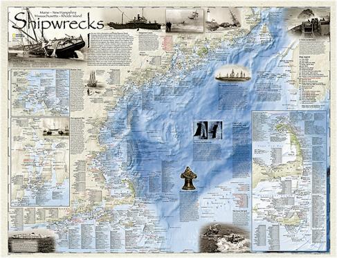
National Geographic Maps, 2011. "Shipwrecks of the Northeast" is a stunning new map illustrating more than 5,400 known shipwrecks on the untamed Atlantic coast of New England (Maine, Massachusetts, New Hampshire and Rhode Island). From Rhode Islands' Narragansett Bay to Maine's St. Croix River, the shipwrecks are clearly marked atop beautiful bathymetric and coastal detail. Each wreck site is symbolized to define the class, type and name of vessel accompanied by the date of sinking. Icons also indicate whether a ship was lost due to conflict or natural causes. Size is 28 x 36 inches.