Captain Segulls
Texas Gulf Coast Sportfishing and Nautical Chart Package Great Savings on 9 Charts
Texas Gulf Coast Sportfishing and Nautical Chart Package Great Savings on 9 Charts
Couldn't load pickup availability

Charts are designed for the serious sport fisherman. They show you fishing spots that will help you catch fish. All charts are laminated, waterproof and in full color. Average Large chart size is 19″ X 26. Charts highlight latitude and longitude (GPS), Loran lines, contour lines, shore services such as fuel docks, loading ramps, kayak launches, pump-out stations and restaurants. Also highlighted are fishing holes with local names, coordinates of buoys, inlets, reefs, rigs and wrecks
Texas Gulf Coast Fishing and Nautical Chart Package
Free USA Shipping
Package Includes 9 Charts
Texas Laguna Southern Madre-LMS52
One side of the chart cover 20 - 30 miles off the coast the other side of the chart covers 1 -2 miles with details of the bays. Chart is 19 x 26 inches, double sided, and laminated, Texas Coast line.
Side A: Nearshore chart from Rio Grande to the Port Mansfield channel, with inset of Port Isabel Area. Side B: Inshore/ICW chart from Stover Point to Chubby Island, with inset of the Arroyo Colorado. All charts include GPS coordinates, rigs, wrecks, reefs, shoals, fishing areas, amenities and restrictions. Please refer to our offshore chart in this area.
Texas San Antonio Area-SA57
One side of the chart cover 20 - 30 miles off the coast the other side of the chart covers 1 -2 miles with details of the bays. Chart is 19 x 26 inches, double sided, and laminated, Texas Coast line.
Side A: Nearshore Matagorda Light to Aransas Pass. Side B: Inshore/ICW Espirito Santo Bay to Carlos Bay including San Antonio Bay. All charts include GPS coordinates, wrecks, reefs, rigs, shoals, fishing areas, amenities and restrictions. Please refer to our offshore chart in this area. Uses NOAA Charts 11313 & 11315
Texas Matagorda to Aransas Pass-MAP56
One side of the chart cover 20 - 30 miles off the coast the other side of the chart covers 1 -2 miles with details of the bays. Chart is 19 x 26 inches, double sided, and laminated, Texas Coast line.
Side A: Nearshore 20 to 30 miles off the shore, Matagorda Light to Aransas Pass. Side B: Inshore/ ICW Carlos Bay to Redfish Bay & Capano Bay with an inset of St Charles Bay. All charts include GPS coordinates, wrecks, reefs, rigs, shoals, fishing areas, amenities and restrictions. Please refer to our offshore chart in this area. Uses NOAA Charts 11313, 11314
Texas Northern Laguna Madre-LMN53
One side of the chart cover 20 - 30 miles off the coast the other side of the chart covers 1 -2 miles with details of the bays. Chart is 19 x 26 inches, double sided, and laminated, Texas Coast line.
Side A: Nearshore chart from Port Mansfield channel to Penascal Rincon. Side B: Inshore/ICW from Peyton’s Bay to Middle Ground. All charts include GPS coordinates, rigs, wrecks, reefs, shoals, fishing areas, amenities and restrictions. Please refer to our offshore chart in this area. Uses NOAA Charts 11304 & 11306
Texas Galveston to Rio Grande River-GRG51
Offshore chart 90 to 100 miles off coast, Double sided, laminated, 19 x 26 inches. Texas Coastline
Offshore from Galveston to the Rio Grande River. 100 to 150 miles off the coast. All charts include GPS coordinates, wrecks, reefs, rigs, shoals, fishing areas, amenities and restrictions. Please refer to our nearshore/inshore charts in this area.
Texas Corpus Christi Bay Area-CC55
One side of the chart cover 20 - 30 miles off the coast the other side of the chart covers 1 -2 miles with details of the bays. Chart is 19 x 26 inches, double sided, and laminated, Texas Coastline.
Side A: Nearshore chart from Aransas Pass to Baffin Bay. Side B: Inshore detail of Corpus Christi Bay. All charts include GPS coordinates, wrecks, rigs, reefs, shoals, fishing areas, amenities and restrictions. Please refer to our offshore chart in this area Uses Charts 11307 & 11309
Texas Baffin Bay Area-BAF54
One side of the chart cover 20 - 30 miles off the coast the other side of the chart covers 1 -2 miles with details of the bays. Chart is 19 x 26 inches, double sided, and laminated, Texas Coast line.
Side A: Nearshore chart from Aransas Pass to Baffin Bay. Side B: Inshore/ICW Redfish Bay to Middle Ground Baffin Bay detail. All charts include GPS coordinates, wrecks, rigs, reefs, shoals, fishing areas, amenities and restrictions. Please refer to our offshore chart in this area
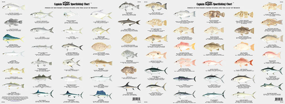
Fishes of the Gulf of Mexico and Florida Identification Chart-FG504
Shark Identification Chart SK502