Fishing Hot Spots
Truman Reservoir-South (South of Hwy 7) Fishing Wall Map-L164
Truman Reservoir-South (South of Hwy 7) Fishing Wall Map-L164
Regular price
$35.95 USD
Regular price
Sale price
$35.95 USD
Unit price
per
Shipping calculated at checkout.
Couldn't load pickup availability
Free USA Shipping
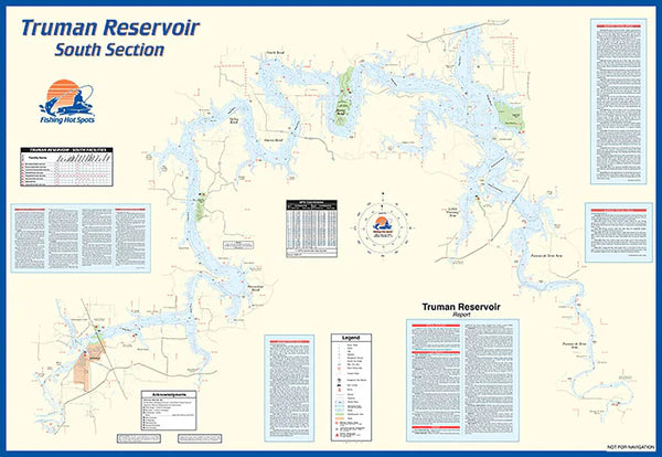
- Truman Lake is the largest flood control reservoir in Missouri, and is a popular angling destination for bass and crappie enthusiasts. More than 150,000 acres of public land surrounds the lake, offering excellent recreational opportunities. Featured Species: Largemouth Bass, Channel Catfish, Blue Catfish, White Bass, Hybrid Striped Bass, White Crappie and Catfish Map Features: Lake Profile, Fishery Information, Fishing Tips and Techniques, GPS Information, 8 Accesses, 36 Proven Fishing Areas Marked
- Type: Wall Map
- Subtype: Fishing
- Language: English
- Regions Covered: Central U.S., North America
- Countries Covered: United States
- States Covered: Missouri
- MPN: L164_Wall
- Folded Size: N/A
- Unfolded Size: 29" (W) x 42" (H)
- Weight: 1 lb